
دراسة
تصميم وتنفيذ نظام معلومات جغرافي SIG
لتسيير
المجال – حالة: ولاية سطيف
مذكرة مقدمة لنيل درجة الماجستير في التهيئة العمرانية الإقليمية
فرع التهيئة الإقليمية - قسم التهيئة العمرانية
كلية علوم الأرض الجغرافيا والتهيئة العمرانية
جامعة منتوري
قسنطينة / الجزائر
إعداد
الطالب
نبيل
سليماني
إشراف
الأستاذ
الدكتور
جمال
رحام
جوان
2009م

الملخص: شهدت العشرية الأخيرة تطوراً غير مسبوق في
مجال المعلوماتية والاتصال، والاستشعار عن بعد ونظام SIG
وازداد استخدام التقنيات الحديثة، كنظم المعلومات الجغرافية و هو
ما خلق نوع من الدينامكية في مجال التخطيط، وتنفيذ، GPS
تحديد المواقع العالمي المشاريع والخطط و البرامج التنموية نتيجة
استخدام هذه التقنيات في تسيير المجال، وتمتاز هذه التقنيات الحديثة بتوفرها على
أدوات متكاملة لمعالجة البيانات، ووظائف متعددة وقدرات كبيرة في التحليل ودعم إتخاذ
القرار، حيث يمكن الاستفادة منها في مختلف مجالات التخطيط وحل المشاكل المعقدة والمتداخلة،
فهي تقدم الدعم التقني والفني لصناع القرار والمسيرين للمجال لإتخاذ قرارات متوازنة
فيما يتعلق بالموارد الطبيعية و البشرية، وتسهم في وضع أحسن الخطط التنموية، و تطوير
البحوث العلمية التي تتطرق لرفع مستوى التقدم للمجتمع والمجال، وتحقيق الحكم الراشد
والتنمية المستدامة للإقليم. يهدف البحث لدراسة تصميم و تنفيذ نظام معلومات جغرافي
إقليمي شامل لتسيير المجال، من خلال دراسة حالة ولاية سطيف لتحديد الإمكانيات والعوائق
المجالية و التنظيمية والتخطيطية لمجال الدراسة، وكذا المتعلقة بتنفيذ النظام في المجال.
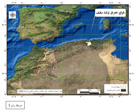
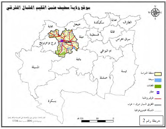
وتم اختيار الولاية نظراً لموقعها الجغرافي، ووزنها البشري والاقتصادي في إقليم الشمال
الشرقي الجزائري، و في الجزائر، حيث تعد الولاية الثانية سكانيا بعد العاصمة، وتضم
داخل مجالها عدد كبير من البلديات (6 بلدية)، مما يطرح إشكاليات مواجهة ومعالجة المشاكل
التي تعيشها الولاية بصفة دقيقة ومعمقة، وهذا لا يتم إلا بوجود أداة فعالة لتسيير المجال
(نظم المعلومات الجغرافية) للتغلب على مواطن الضعف في التسيير، وتوفير البيانات الدقيقة
و الحقيقية وإعداد السيناريوهات اللازمة لدعم إتخاذ القرار.
Abstract:
The last decade has been characterized by an expansion and amplification
unprecedented in research and increased use of areas of computing,
communications and new spatial analysis techniques such as GIS, remote sensing
or positioning Geographic GPS in different areas of investigation of a space.
These processes have contributed effectively to the provision of a certain
dynamism and beneficial in the areas of modeling geographic space, planning and
implementation of various projects. In addition, these new tools,
multifunctional, with the capacity to support a mass of invaluable information
multifaceted and filled several modules processing and analysis have become
essential for the different actors space because they support them fully in
rapid assimilation of the phenomenon studied space, good governance and to take
appropriate decisions. For this modest work, which does not claim to be the
precursor and which do not lack without doubt shortcomings, we tried to
establish a Geographic Information System for the wilaya of Setif, which is
characterized by a dynamic economy apparent, which is the second most populated
district of Algeria and to have a wide range of topography. Our major concern
is much more to open a new front for the research that lead to a finalization
Résumé:
La dernière décennie s'est caractérisée par un développement et une
amplification sans précédent dans la recherche et l'utilisation accrue des
domaines de l'informatique, de la communication et des nouvelles techniques
d'analyse spatiale comme les SIG, la télédétection ou le positionnement
géographique par GPS dans les différentes thématiques d'investigation à
caractère spatial. Ces procédés ont contribué efficacement à l'apport d'un
dynamisme certain et avantageux dans les domaines de la modélisation de
l'espace géographique, la planification et la mise en oeuvre de différents
projets. Par ailleurs, ces nouveaux outils à caractères multifonctionnels,
ayant la capacité de prendre en charge une masse inestimable d'informations multiformes
et pourvus de plusieurs modules de traitement et d'analyse, sont devenus
incontournables pour les différents acteurs spatiaux car ils les soutiennent
pleinement à une assimilation rapide du phénomène spatial étudié, à une bonne
gouvernance ainsi qu'à la prise de décisions appropriées. Par ce modeste
travail de recherche, qui ne prétend pas être précurseur et qui ne manque sans
pas doute d'insuffisances, nous avons tenté de mettre en place un Système
d'Information Géographique pour la wilaya de Sétif qui se caractérise d'un
dynamisme économique apparent, qui est la seconde circonscription la plus
peuplée d'Algérie et qui se dote d'une grande diversité topographique. Notre
préoccupation majeure est beaucoup plus d'ouvrir un nouveau front pour la recherche
que d'aboutir à une finalisation
المفردات
الاستدلالية: نظم المعلومات الجغرافية، تسيير المجال، قاعدة المعلومات، ولاية سطيف،
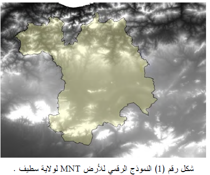
مشاريع التنمية، الاستثمار، البيانات، التحليل المكان ، النموذج الرقمي للارتفاع،
البعد الثالث، الخرائط الرقمية، النموذج الخطي، النموذج الشبكي، الاسقاط الجغرافي،
البعد المجالي، تكامل البيانات، التطابق.


تحميل الرسالة